Waders at RSPB Snettisham on The Wash
_Natural wonder of Norfolk: The Wash and Hunstanton cliffs
Important wetlands and the largest estuary system in the British Isles
Standing on the cliffs at Hunstanton are a perfect place to view the massive bay and estuary of The Wash and enjoy spectacular sunsets as the fading light plays on the westward-facing multi-coloured cliffs. Hunstanton is the only west-facing seaside town on the east coast.
The remarkable multi-coloured cliffs rising some 20 metres demonstrate Norfolk’s solid geology from the Cretaceous Period – the layers demonstrating the changing sea levels more than 100 million years ago.

Hunstanton cliffs
At the bottom is Carstone, from the Lower Cretaceous period, 146 to 140 million years ago, a brown iron-rich form of sandstone which you’ll see in buildings around the west of Norfolk, including Sandringham village on the estate of the Royal Family.
Above the Carstone is red chalk, its colourisation the result of proximity to the Carstone. The sequence is topped by white chalk.
This is an excellent location for fossil hunting including ammonites and belemnites.
Beneath the cliff is another striking landscape, a series of grey-brown Carstone outcrops that have been eroded by the sea into a series of rectangular, grid-shaped formation. Each block carries a curious square-shaped feature known as a Liesegang ring, created by percolating water from the adjacent joints and bedding planes.

Illuminated Kings Lynn Minster on the River Ouse at King's Lynn
The Wash extends round to the mouth of the River Great Ouse at King’s Lynn and the start of the Fens. The coastline of Lincolnshire is in the distance.
The Wash is one of the most important wetlands in Europe and the largest estuary system in the British Isles, spanning 20km across and 30km in length. Its shape was gouged by the last Ice Age, from 350,000 to 10,000 years ago. When the ice retreated, the rivers Great Ouse, Welland and Nene flowed into the depression.
It was through The Wash that Viking raiders sailed into Thetford, before killing Anglo Saxon King Edmund, the first patron saint of England and after who Bury St Edmunds is named.
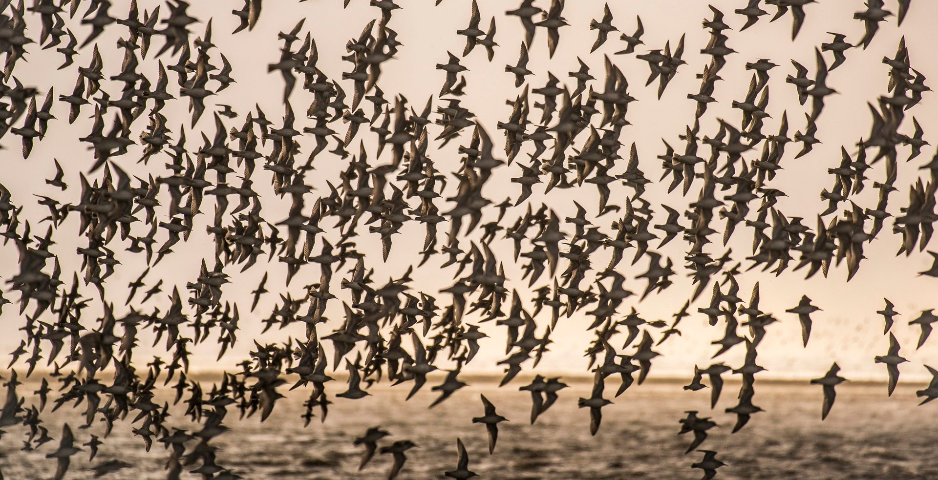
The vast expanse of mudflat is covered twice daily by the North Sea and it provides a range of habitats, including saltmarsh, shallow waters, deep channels, sandy and shingle beaches, and shoreside lagoon where wading birds flourish.

Flock of Knot at Snettisham
The receding tide unveils a feast of highly nutritious morsels, with the mud containing an abundant source of marine worms, small fish and shellfish. Crucially, The Wash is a comfortable and safe resting and roosting space with potential predators unable to cross the mud.
Snettisham is an excellent place to see murmurations of seabirds and waders. It is renowned for its clouds of migratory birds which can cover the sky, particularly in the winter migration period when tens of thousands of pink-footed geese fly overhead in their distinctive skein formations at dawn and dusk.
They are going inland to feed off the tops of harvested sugar beet left behind by farmers. Interestingly, there was a period when the farmers ploughed the tops back into the fields. The next year the geese disappeared, only returning when farmers reverted to leaving the tops.

Waders in a lagoon at Snettisham
The Wash is also a focus of the annual East Atlantic Flyway, particularly at RSPB Titchwell and Snettisham, when tens of thousands of wading birds, geese and ducks can be seen on these wetlands throughout the autumn and winter.
The East Atlantic Flyway, which incorporates the coastline of East Anglia, is one of a few major global migration routes, when birds move between their breeding areas and the places they spend the winter. It stretches from the tip of South Africa right through to the Arctic Circle. For coastal birds such as waders, the route flows up the west coast of Africa, around Spain, Portugal and France.
These migratory routes are used by many different types of birds including wading birds and other waterbirds such as black-tailed godwit, dunlin and a wide range of duck and goose species and are likely to have been used for generations.
The routes are so globally important that they have been added to the UK’s shortlist for World Heritage sites and are much like aeroplane flight paths, with designated stopovers for re-fuelling.
From Hunstanton there are seasonal boat trips to visit the offshore seal colony.

Looking at The Wash from Hunstanton beach at sunset
Other Natural Wonders of Norfolk

Natural wonder of Norfolk: River Wensum and chalk streams
In the country’s driest and flattest county, you’ll find a series of spring-fed chalk rivers that…

Natural wonder of Norfolk: The Brecks
Described by Charles Dickens as ‘barren’ in David Copperfield, and by an observer in the 1760s as…

Natural wonder of Norfolk: Chalk Reef
Dubbed ‘Britain’s Great Barrier Reef’, the Cromer Shoal Chalk Bed, created when dinosaurs ruled the…

Natural wonder of Norfolk: Flint
If there’s one material that’s synonymous with Norfolk then it’s flint. You’ll see it everywhere,…

Natural wonder of Norfolk: The Cromer Ridge
Cromer Ridge is the highest coastal area of East Anglia at over 100 metres, is 8.7 miles long, and…

Natural wonder of Norfolk: Cromer Forest-Bed
The Cromer Forest-Bed Formation, aged between 500,000 and 2 million-years-old and stretching from…

Natural wonder of Norfolk: Blakeney Point
Managed by the National Trust since 1912 and within the Norfolk Coast National Landscape, Blakeney…
Other Natural Wonders of Norfolk
Natural wonder of Norfolk: River Wensum and chalk streams
In the country’s driest and flattest county, you’ll find a series of spring-fed chalk rivers that…
Natural wonder of Norfolk: The Brecks
Described by Charles Dickens as ‘barren’ in David Copperfield, and by an observer in the 1760s as…
Natural wonder of Norfolk: Chalk Reef
Dubbed ‘Britain’s Great Barrier Reef’, the Cromer Shoal Chalk Bed, created when dinosaurs ruled the…
Natural wonder of Norfolk: Flint
If there’s one material that’s synonymous with Norfolk then it’s flint. You’ll see it everywhere,…
Natural wonder of Norfolk: The Cromer Ridge
Cromer Ridge is the highest coastal area of East Anglia at over 100 metres, is 8.7 miles long, and…
Natural wonder of Norfolk: Cromer Forest-Bed
The Cromer Forest-Bed Formation, aged between 500,000 and 2 million-years-old and stretching from…
Natural wonder of Norfolk: Blakeney Point
Managed by the National Trust since 1912 and within the Norfolk Coast National Landscape, Blakeney…
Stay In Touch
Sign up for our newsletter for Norfolk holiday ideas, places to stay, seasonal guides and local events. We’ll share inspiration for days out, coastal breaks and countryside escapes, plus occasional highlights from across the county.
